WaterModifier
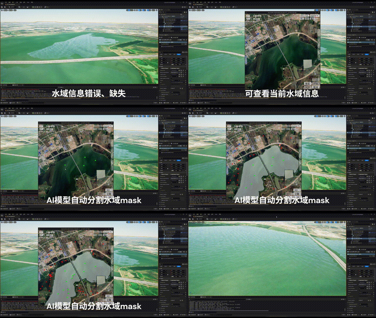
An AI-assisted desktop tool for editing water masks in geospatial terrain datasets. Browse a satellite tile map, click a few foreground / background points, let Segment Anything extract the water region, and write the result directly back into Cesium quantized-mesh .terrain tiles — automatically synchronized across LOD levels. Validated on a real GIS dataset (Yaohu Airport, maxzoom 18).
Built as two cooperating processes: an Unreal Engine 5.4 frontend (map browsing, visualization, interaction) and a Python backend (SAM inference + terrain file surgery), talking over a TCP socket with a length-prefixed protocol.
Why this exists
In a Cesium quantized-mesh dataset the water mask is not a layer you can open and save on its own — it lives as an extension record at the tail of every individual .terrain tile file. Its offset is not even fixed: you have to skip the 88-byte header, then step over the vertex data, the triangle indices (index width switching between 2 and 4 bytes depending on triangle count) and the west / south / east / north edge-index lists, each by its own length prefix, before you can scan the extension records and find out whether type 2 is there at all. The same body of water is also duplicated down the LOD pyramid — edit one level and every level below has four times as many tiles needing the same change.
So a human-scale editing intent — “this reservoir should be water” — lands on the data as byte-level rewrites of thousands of tile files. WaterModifier exists to connect those two ends: a tile pyramid laid out on screen at true geographic coordinates and a few mouse clicks on one side, bulk binary rewriting and level-by-level propagation on the other.
Frontend (UE 5.4, C++)
- 🗺️ TMS tile-map browser — top-down orthographic camera with drag / scroll-zoom; the tile manager diffs the viewport’s tile range each frame and streams in only newly visible tiles
- 🌐 Live geo-coordinates — real-time lat/lon readout derived from the tileset’s
units-per-pixelmetadata; LOD switching re-anchors the camera to the same geographic position - 💧 Water-mask visualization — parses the quantized-mesh
.terrainbinary format directly in C++ (vertex / index blocks, edge indices, then the extension records — extension type 2 is the water mask) and overlays existing water in blue
Backend (Python + PyTorch)
- 🤖 SAM segmentation — the current viewport is exported as EXR, tone-mapped, and fed to Segment Anything (ViT-B, CUDA); left-clicks are foreground prompts, right-clicks background — iterate points until the mask is right
- ✍️ Manual mode — Photoshop-pen-style polygon selection, rasterized with ray-casting point-in-polygon tests
- 📝 In-place terrain editing — per-tile mask merge supporting both overwrite and additive modes, handling uniform 1-byte masks and full 256×256 masks, and appending the water-mask extension to tiles that never had one
- 🧹 Morphological cleanup — opening / closing passes remove segmentation noise, followed by smoothing convolutions so edited water edges blend naturally
- 🔁 LOD synchronization — edits recursively propagate to higher zoom levels by quadrant-splitting the parent mask and nearest-neighbor upsampling, all the way down to the dataset’s max LOD
- 📊 Live progress — a timer thread streams the modified-tile count back to the UI every 0.5 s during bulk writes
Key engineering points
- Dual-end binary format consistency — Cesium quantized-mesh-1.0 is parsed twice, once per end: Python implements the writer (manually walking header / vertex blocks / index blocks / edge blocks / extension records, with 2/4-byte index width chosen by triangle count), UE C++ implements the reader (visualization) — both ends must agree byte-for-byte on the format
- Camera ↔ tile coordinate chain — a C++ function library implements the full pipeline from camera view → tile numbers → geo-coordinates (including tilemapresource.xml parsing and
units-per-pixelconversion)
Design decisions and trade-offs
- 🔌 Commands over the socket, pixels over the filesystem — the protocol carries only command keywords plus string arguments (click coordinates, LOD, terrain root, bottom-left tile indices, ortho width, tile size), with short replies like
SegmentDone/ModifyDone. The two images are handed over as files in the working directory instead: UE exports the current viewport’s render target as EXR for Python to segment, and Python writes a mask PNG that UE reloads as a runtime texture. The rejected alternative was pushing pixel buffers through the socket; the cost is that both processes are pinned to one shared working directory. - 🧭 Walking segment by segment rather than seeking to the mask — the mask offset depends on the vertex count, triangle count and index width, so a fixed offset is not an option and the code steps through using each segment’s own length prefix. The cost is that the same traversal is implemented twice — Python writes, UE C++ reads — and both sides’ understanding of field offsets and skip rules has to stay in step permanently.
- 📦 The writer always emits the full grid — a mask payload is either a 1-byte uniform all-water / all-land flag or a full 256×256 = 65,536-byte grid. A 1-byte payload is promoted outright: rewrite the length field, drop that single byte, append the full grid; a tile with no mask extension at all gets one appended at the end of the file. Keeping the compact 1-byte form would save space but would require two branches at every downstream site; the cost as built is a whole-file read-modify-rewrite rather than an in-place byte patch.
- 📄 Three filenames as the dataset contract — the tile-map root must hold
tilemapresource.xml(supplying the per-LOD units-per-pixel list) andmeta.json(supplyingmaxzoom), and the terrain root must holdlayer.json.maxzoomcomes from a file rather than being inferred from the pyramid on disk: the benefit is predictable behaviour with no directory scan, the cost is that a dataset has to provide that file by convention. - ⏱️ Progress reported by a self-re-arming timer — during a bulk edit a 0.5 s timer writes the completed tile count back to the UI, incrementing once per
.terrainfile written, including recursively synced children. It is simple and stays out of the write loop; the cost is a stream that bypasses the length-prefixed protocol and has to be recognized separately on the receiving end.
Tech stack
UE 5.4 / C++ · Python / PyTorch — segment-anything (ViT-B), NumPy / SciPy / OpenCV, TcpSocketPlugin; operates on TMS tile pyramids and Cesium quantized-mesh-1.0 terrain. Segmentation uses SAM ViT-B (segment_anything pinned to a specific upstream commit, torch 2.4.1 + cu124); the UI offers five ortho-width settings — 256 / 512 / 768 / 1024 / 2048 — with 1024 as the default.